
Over the years, we have maintained the best technology for mobile communications. Obtaining weather data from places as remote as a cornfield in eastern Montana is sometimes challenging. Cellular coverage has been spotty at best in many parts of Tornado Alley. As a result, we once used the same Internet satellite communication hardware employed on the Doppler-on-Wheels (DOW) trucks. We still maintain the best state-of-design systems available. This guide will help you learn about storm chasing technology of the past and present and the gear that we currently use that will make your storm chasing adventure with us successful.
A Quick Note about (Marine) Radar Antennas
Some tour operators are either making false claims or violating several federal laws in regard to using radar antennas. It is illegal to operate radar antennas from a vehicle without the proper licensing by the Federal Communications Commission (FCC). It is a violation of section 301 of the Communications Act of 1934 and of 47 CFR § 80.13 FCC rules to operate marine radar on land (fines start at about $8,000). Licenses to operate mobile radar antennas are limited to government and academic research.
The radar units that some tour operators are claiming to use are marine radar antennas. They are intended to be used on boats, and boats only. They can’t even be used if the boat is dry docked, the vessel literally has to be in the water.
The FCC does not grant licenses for marine radar antennas to be used on land, much less on land-based mobile platforms. The primary reason is that these units interfere with NWS operational radar as well as research radars that academia has deployed around a storm environment.
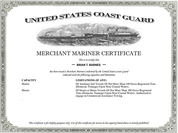
Our tour leader, Brian Barnes, is also a Master Captain, licensed by the U.S. Coast Guard. When he’s not chasing storms, he’s commanding seagoing voyages. He also owns a fleet of commercial boats, each with a marine radar.
Brian has the appropriate licensing from the FCC to operate these radar units on his boats. And as a Master Captain, he understands marine and radio law very thoroughly. It would be easy for him to use one of his radars on our storm chasing vans. However, it would be illegal.
Pertaining to marine vessels, there are several licensing steps that have to be completed to have an operational marine radar. The first is that the vessel itself has to have a “Ship License” for the radar to be installed. Once that is done, any crew member who uses the radar in their duties to keep watch has to also have a “Radar Endorsement” on their personal FCC license. For those interested, that is FCC Element 8 on the General Radiotelephone Operator License (GMDSS).
So, be careful if you sign up with a tour company that operates illegal radar. You won’t end up in trouble as a customer, but the tour might be cut short when the vehicle is impounded if that were to happen. And, all it would take is for Oklahoma University or the Doppler-on-Wheels to make a phone call to the FCC and complain their radar is experiencing interference.
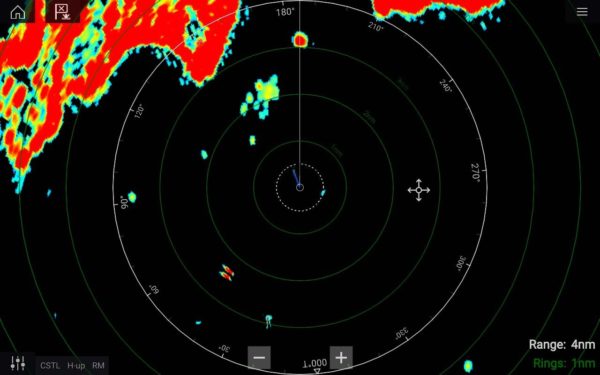
What really doesn’t make sense about these claims is that the radar information available from the NWS is of much higher resolution than marine radar anyway. These radar systems are designed to be used at sea where there isn’t a (better) NWS radar installed. Take a look at the comparison below. The first image is a typical modern marine radar display. The second is the Super-Resolution of Level II Data from the National Weather Service. Which would you rather chase with? Yeah, us as well!
As a result, we can only assume companies that make claims like this are preying upon unsuspecting potential customers. They want their customers to think they’re “cool” and have some whacky gizmo nobody else has. Brian has five of them. They are legally installed and used on his commercial boats. We can’t legally use them on our storm chasing vehicles. We wouldn’t even if we could because there is better data available. The radar software that we do have while storm chasing is of magnitudes better.
Read on to learn more about the software and technology that we use to forecast and intercept severe storms.
What Sets Us Apart from Our Competitors
All storm chasers use a few common applications, which we will talk about below. Our storm chasing team uses a combination of commercially available software and our own custom data products. There are two things that set us apart.
We lease and maintain our own weather modeling server that is continuously working in the background while we’re storm chasing. Our servers run software designed for linux called GEMPAK that create the tailored forecasting models that we use for successful storm interceptions.
This is the same software used by many government weather forecasting offices. The difference is, our version allows us to select only the parameters that we’re most interested in and as a result, creating a custom solution.
Our servers constantly crunch data to create custom forecasting models with the exact severe weather parameters we want to see. They are also ingesting our own data feeds for the radar software that we use. We obtain data from satellite connections at a datacenter. Our servers then format these data to our specific needs and allow us to retrieve that data using commercial software.
We use Private Data Feeds
From time to time, public data feeds from the National Weather Service or commercial vendors may crash during high demand as loads increase on public servers. We don’t have this problem since we use our own private servers to get the data we use! As always our technology is state-of-the-art; we even have the ability to use a tablet to control, operate and manipulate our servers from anywhere in Tornado Alley!
What really sets us apart however is our ability to interpret forecast data to create the most accurate forecasts! Not every member of our team will physically participate on our storm chasing tours. Our meteorologists are constantly analyzing forecasting data while we are conducting our tours. Every team member can easily communicate and collaborate to create a top-notch forecast that works to our advantage.
The Early Years
In the late 90s, the Internet was still in its infancy. Most of the technologies we use today simply didn’t exist. Mobile phones were growing rapidly in popularity, but were still overly expensive to use “per minute.”
During a typical storm chase in the 90s and early 2000s, we made several stops in order to use a payphone. This allowed the tour leader to discuss the weather synopsis with our nowcasting team. Nowcasters constantly monitor weather data and perform detailed mesoscale analysis. They then relay that information to our team leading the storm chasing tours.
Aside from payphones, we commonly stopped at a public library when possible to access the Internet from their dial-up connection. As time went on, we traded public libraries for WiFi hotspots and knew every hotspot location in Tornado Alley! In those days, hotels that offered free WiFi would have parking lots filled with storm chasers in the mid-afternoon hours.
Before it was possible to get weather data from the Internet, we would even visit a National Weather Service office. These visits allowed us to view the current numerical data and discuss the forecast with their meteorologists.

Satellite Communications
In the early 2000s, we needed a system that allowed us Internet access from our storm chasing vans. Cellular communications were not reliable at the time and we needed reliable forecasting data. Additionally, we needed a way to upload storm chasing videos to news networks for distribution. The solution was DataStorm. A mobile internet satellite system that provided high-speed internet access. Today, 4GLTE has replaced the services that DataStorm once provided. The Doppler-on-Wheels (DOW) vehicles continue to use DataStorm. They go overseas and still operate in areas with no cellular communications.

There were major drawbacks to this system, however. For one, it took about 15-minutes to get a lock on the satellite. When you’re storm chasing, 15-minutes can seem like hours. Secondly, the slightest amount of wind could break the “lock” it had on the satellite. This would cause the dish to begin realignment again (another 10-15 minutes). This was a common problem due to it being windy on storm chasing days.
XM Weather (XMWX) Communications
In 2004 storm chasing received its first major mobile communications breakthrough. Baron’s Mobile Threat Net used a tiny XM antenna and receiver. This system ingests live weather nowcasting information such as radar updates and live surface observations every 5-minutes. Further, it worked surprisingly well under 60,000 feet of towering cumulus.
This system allowed us to obtain weather data without the need to stop for satellite alignment. But once again, there were major drawbacks while using this system. The biggest drawback was the quality of the data. The data on this system is low-resolution. Compressing the data stream allowed it to stream over the satellite network. But it also meant the end-user had fewer pixels to work with.
As cellular communications became more dependable in Tornado Alley, we discontinued the usage of XM weather data in 2013.
GRLevel3 Windows Application

To our advantage, AT&T and Verizon began deploying more cellular towers throughout the Great Plains. Having a larger coverage area and faster data speeds meant we could now use our primary software packages. One of those applications that we commonly use is GRLevel3.
The great thing about this software is that it doesn’t have to rely on a single source of data. In fact, our private servers ingest data from multiple locations and create our own data stream. In the event that our servers become unavailable, we can fallback to public data if needed.
GRLevel3 is more than just a viewer application of live weather radar. This Windows software allows customization of the data in a number of ways. It is capable of displaying frontal movement information, station plots and even data from the Storm Prediction Center.
Like Mobile Threat Net, the data stream in GRLevel3 is low-resolution. Although, its a higher resolution than Mobile Threat Net. Still, there is a loss-of-quality in pixel information. Despite this, it is sufficient enough to get a very clear idea of a storm’s mode.
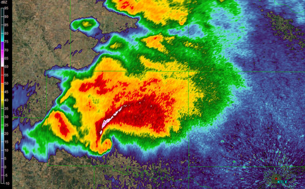
As an example, the image here shows a very well defined hook echo on the supercell to the north. This kind of clarity wasn’t available with the Mobile Threat Net system.
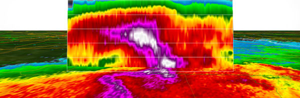
Level II Data is our Workhorse!
We use Super-Resolution Level II data. This is like the big brother to GRLevel3 and runs in a similar Windows-based software application. There are applications available for Linux and macOS environments. However, GRLevel II is the easiest to use while storm chasing. Another application that runs on most mobile platforms is RadarScope, which uses the same super-resolution Level II data stream.

If you look at the example images that we have provided here and compare the RadarScope screengrab to the left to the GRLevel3 and Mobile Threat Net images above, not only can you easily determine the hook echo radar signature, but there are a lot more pixels! In addition to the super-resolution, the data stream is 99 percent reliable and fast. We receive the data nearly as fast as forecasters at The National Weather Service receive the data. Considering where we were just 10-years ago, that’s incredible!
Where We Are Today
We removed the DataStorm system from the chase van in 2017. That system is now used on an emergency communications trailer called EM-COMM 1. We built EM-COMM 1 after Hurricane Irma and loan it to emergency management offices that need communications during disasters.
DataStorm is perfect for these needs as it still provides reliable high-speed Internet-based mobile communications. After major disasters it is common for cellular communications to be non-functional, making satellite communications a required priority. And, this is our way of helping the emergency management community.
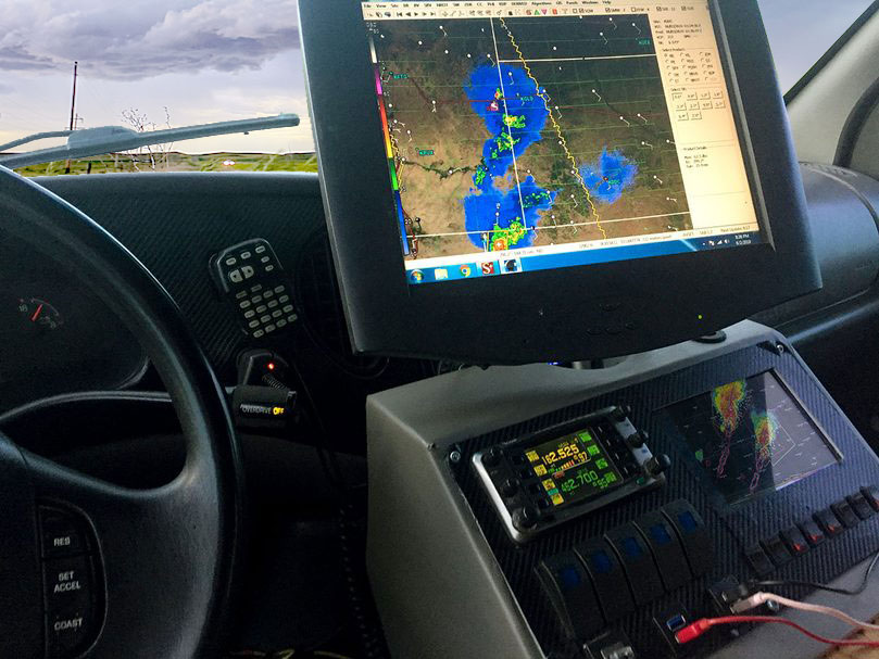
While storm chasing, we use a combination of Verizon, AT&T and another cellular provider specific to Colorado. We have one little device that uses all of these networks together. This device automatically switches us to the fastest and nearest tower location. The lead chase van has a workstation computer installed in it with the same touchscreen monitor we’ve used for years. Additionally, it also has a tablet built-in to the main console, as well as, radio communication equipment.
Aside from the primary workstation, we also employ our laptops and the van distributes our cellular data via WiFi.
Other Products We Use

Storm chasing requires more than just weather data. For successful storm interceptions, a chaser must have a complete Geographical Information System. Mapping and route planning are essential.
Over the years, we have depended on software produced by DeLorme called Street Atlas. The company provided annual updates of the software and it had the most detailed maps of Tornado Alley. Even better, being a GPS based application, it plotted our position live on the map.
A few years ago Garmin acquired DeLorme and discontinued many of their products, including Street Atlas. Fortunately, the rural road network of Tornado Alley doesn’t change that often. Map updates primarily pertained to major highways and of those most of them in urban areas.
For our purposes, we are not really concerned with urban road networks or changes to the Interstate system. We are concerned with rural farm roads. For these concerns, the last version of Street Atlas will be just as effective 20-years from now as when the product launched.
As a result, we continue using this discontinued product. And we also continue to ask Garmin to bring this product back to the market. The company feels that the product couldn’t compete with Google Maps and other online GIS products. We disagree.
No other product came close to the accuracy of the rural road network of the Great Plains than DeLorme’s Street Atlas! In fact, a quick search of the Internet shows why Google Maps is an inefficient product when dealing with rural roads. For example, here is a news story where 100 people became stuck after Google Maps incorrectly routed them down a muddy trail.
Radio Communications
Most people today think of Amateur Radio as outdated technology antiquated to the likes of fax machines. Nothing is further from the truth. Like most technologies, amateur radio has evolved over the decades and today provides reliable digital communications.
It has the advantage of also providing regular radio communications when digital communications become unavailable. More importantly, most National Weather Service offices still have amateur radio equipment installed and monitored during severe weather events.
We do not use amateur radio for commercial purposes, such as communication between vans. We do however use it to monitor information from storm spotters and to relay information to The National Weather Service. Local emergency management operation centers also heavily rely on amateur radio.
We can talk to any of their storm spotters while in the field chasing should the need arise. We consider amateur radio to be an integral part of our rig and encourage others to use it as well. Brian holds a General Class amateur radio license with the FCC callsign WX0USA.
A Note on Live Streaming
In 2015, the company that represents our video to the national media, StormChasingVideo.com, and we ventured into the live streaming market. SCV set up a special server to handle the live streaming needs of their entire storm chasing team at great expense. As a result, we invested in special equipment to be installed in our vehicles. This was top-notch equipment and considered the best on the market. The results were not what we had expected.
We identified several problems with the state of the technology, which created the need to constantly monitor the live streaming equipment. Despite using multiple cellular service providers, there were times when the live stream would drop due to changing towers as we moved. There were further issues in making sure all the cables between the cameras and streaming box stayed connected. The result here is that when we have to devote our time to monitor gizmos and gadgets, it diverts our attention from where it needs to be. Namely, the customers, the road and the forecast.
Further, we have been on many storms with dozens of other chasers and have noticed a trend in cars swerving over the past several years. We didn’t realize until we got into live streaming why this was happening. Storm chasers are paying more attention to monitoring their equipment and pointing their cameras than they are to their driving. Situational awareness is the difference between life and death. We decided in 2016 that our year-long trial period with live streaming didn’t provide us with the result we needed and discontinued live streaming.
As it just so happens, the following year in 2017 there was a fatal accident involving three storm chasers in Texas. The driver who was at fault was live streaming at the time of the accident for The Weather Channel. For whatever reason, and it was probably live streaming, he wasn’t paying attention to the road. He lost situational awareness and ran a stop sign, then hitting another storm chaser at an intersection.
We will not comprise on safety and we feel that live streaming does exactly that. It’s dangerous enough that there are dozens of other drivers operating near storms who may not be paying attention to the road. You can always be sure our drivers are looking out for you. Your safety is our safety and we intend to get us and everyone with us safely back to our base hotel at the end of the tour.
Discontinuing live streaming was our decision, but after talking with the leadership at StormChasingVideo.com, they agreed and the live streaming server was shut down for the entire SCV storm chasing team. We’re proud that our media partners are as responsible and safety orientated as we are.
Summary
Today’s mobile technology is better, smarter, faster and smaller than ever before. As a company, we continue to evolve as new products become available. For some of our needs, the only solution is custom proprietary systems. During the offseason, we spend much time evaluating and creating the systems we need to provide the best storm chasing tours in America.