
Interpreting the Data
In the USA, we typically use three different forecasting models (although there are more). Those models are the Rapid Refresh Model (called the “RUC” or “RAP”) – another ‘version’ is the High-Resolution Rapid Refresh Model, or “HRRR”, The North American Model “NAM” and the Global Forecast System or “GFS”.
Forecasting models are a great tool to get a general idea about what is happening meteorologically above our heads, but they have not traditionally been great at forecasting the weather at the surface, which of course is what is most important to us since that is where we live. Therefore, the skilled forecaster has to interpret the data from the forecasting models based upon their experience. As such, forecasting is just as much of an art as it is a science.
The most important part of any forecast map, model or any other piece of weather information is the time! Forecasters around the world use a common time zone for reference to forecasting based on the time zone in London. It is called “Zulu” time or “Z” time and is not affected by daylight savings. The reason for the global time agreement is that, for example, weather balloons can be launched at about the same time at all points around the world. These are typically launched at 00Z and 12Z. On a forecasting model, you will see two different times. One of them is the time that the model was run and the other is the time of the forecast projection.
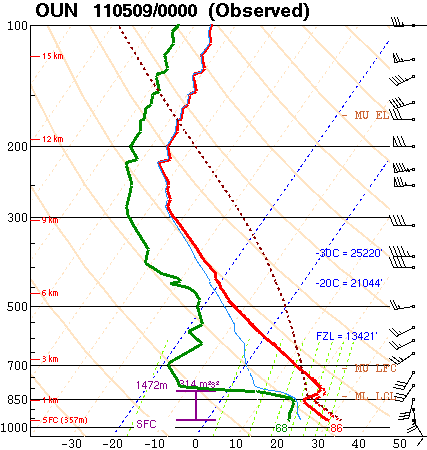
Aside from forecasting models, meteorologists also commonly use a Skew-T/Log-P Diagram as illustrated to the right. This diagram has solid lines running left to the right called Isobars which represent the layers of the atmosphere based on their atmospheric pressure with height.
The temperature is plotted by a line called an Isotherm which runs diagonally from the bottom to the upper-right, so the temperature lines are “skewed,” which gives the Skew-T its name. There are many ways to interpret this diagram and we cover it in vast depth during our storm chasing tours.
On the next page, we’ll discuss the accuracy of the forecast over a period of time. In general, current science as greatly improved the accuracy of short-term forecasts. But as the time scale extends, the forecasts become less reliable. This is due to what we call The Butterfly Effect and Chaos Theory.